How Lidar Is Changing Archaeological Discoveries
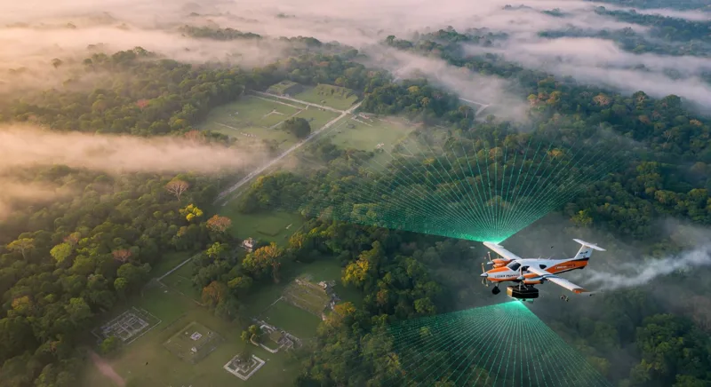
How Lidar Is Changing Archaeological Discoveries is a story about seeing the invisible. By sending laser pulses from aircraft, drones, or handheld scanners, archaeologists can map landscapes hidden beneath forests, vegetation, and centuries of natural change—often without moving a single stone.
What Is Lidar in Archaeology?
Lidar, short for Light Detection and Ranging, measures the time it takes for laser pulses to travel to the ground and return to a sensor. Millions of measurements can then be combined with GPS data to create a highly detailed three-dimensional map of the landscape.
Unlike traditional aerial photography, lidar can often detect subtle changes in elevation. Some laser pulses reflect from leaves and branches, while others pass through gaps in the canopy and reach the forest floor. The resulting “bare-earth” model can reveal roads, terraces, foundations, canals, defensive walls, and ceremonial structures that are difficult or impossible to spot from the ground.
Why Lidar Is Transforming Archaeological Surveys
Traditional archaeological fieldwork is invaluable, but it can be slow, physically demanding, and limited by difficult terrain. Dense rainforest, steep hills, wetlands, and private or protected land may prevent researchers from surveying large areas efficiently.
Lidar changes the process by allowing teams to scan extensive archaeological landscapes quickly. Instead of searching one location at a time, researchers can analyze an entire region and identify promising sites for field verification.
- Speed: Large areas can be mapped in a fraction of the time required for ground surveys.
- Precision: High-resolution elevation data can expose small changes in terrain.
- Minimal disturbance: Researchers can study buried or overgrown landscapes without excavation.
- Landscape perspective: Lidar reveals how homes, roads, farms, reservoirs, and monuments were connected.
- Conservation value: Digital maps help document sites before erosion, development, looting, or climate-related damage occurs.
Discovering Hidden Maya Cities and Ancient Infrastructure
Some of lidar’s most dramatic archaeological discoveries have come from Central America. In the Maya region, airborne laser scanning has revealed extensive networks of residences, temples, raised roads, agricultural terraces, reservoirs, and defensive features beneath thick tropical vegetation.
A lidar survey around the Maya city of Caracol in Belize identified thousands of structures, causeways, agricultural terraces, and other landscape modifications across a broad area. The results showed that the city was not simply a collection of monumental buildings; it was part of a sophisticated urban and agricultural system.
Similar surveys in Guatemala and Mexico have identified large settlement networks and previously unknown structures. One survey in the Mirador-Calakmul region documented hundreds of sites and extensive raised causeways, helping researchers reconsider the scale and organization of ancient Maya civilization.
These findings matter because archaeology is not only about discovering individual ruins. It is also about understanding population movement, food production, transportation, political power, and environmental adaptation.
How Archaeologists Turn Laser Data Into Discoveries
1. Data collection
A lidar sensor is mounted on an aircraft, helicopter, drone, vehicle, or tripod. It sends rapid laser pulses toward the landscape and records their return times.
2. Point-cloud processing
The measurements form a dense three-dimensional “point cloud.” Specialists classify points as vegetation, buildings, soil, water, or other surfaces.
3. Digital terrain modeling
After vegetation points are filtered, researchers create a digital elevation model that represents the ground surface. Shaded-relief images, slope maps, and contour visualizations can make archaeological features easier to recognize.
4. Field verification
Lidar does not replace archaeologists in the field. Researchers still visit selected locations to confirm whether an anomaly is a human-made structure, a natural feature, or a modern disturbance. Excavation, artifacts, dating methods, and local knowledge provide the cultural context that a laser map cannot supply on its own.
Lidar Compared With Traditional Archaeological Methods
| Method | Main strength | Common limitation |
|---|---|---|
| Ground survey | Provides direct observations and artifacts | Slow and difficult across dense or rugged terrain |
| Aerial photography | Shows visible structures and landscape patterns | Vegetation can conceal ground features |
| Satellite imagery | Covers very large areas | Resolution may be insufficient for subtle remains |
| Lidar scanning | Maps terrain and hidden surface anomalies in detail | Can be costly and requires specialized processing |
The Limitations of Lidar Archaeology
Lidar is powerful, but it is not an archaeological “X-ray.” It cannot see through solid ground, so deeply buried sites may remain undetected. Very dense vegetation, poor survey resolution, steep terrain, and unfavorable acquisition conditions can also reduce the quality of results.
Data interpretation presents another challenge. A lidar survey can produce enormous datasets, and distinguishing ancient remains from natural landforms or modern construction requires experience. Researchers must also consider that an elevation map shows physical features but does not automatically reveal their date, function, or cultural meaning.
Access to data can be a further issue. Public lidar datasets may have lower resolution, limited metadata, or processing restrictions that make detailed archaeological analysis more difficult.
Lidar, Cultural Heritage, and the Future
Beyond discovery, lidar supports archaeological site management. Digital terrain models can help heritage professionals monitor erosion, vegetation growth, illegal construction, and other threats. Three-dimensional documentation also creates a valuable record of sites that may later be damaged or altered.
The next phase will likely combine lidar with drone photography, artificial intelligence, geographic information systems, ground-penetrating radar, and environmental data. Machine-learning tools may help identify patterns across massive point clouds, while archaeologists provide the historical and cultural interpretation.
Conclusion: A New View of the Ancient World
How Lidar Is Changing Archaeological Discoveries comes down to one major shift: archaeology can now study entire cultural landscapes rather than isolated ruins. By revealing hidden roads, farms, neighborhoods, and cities, lidar helps reconstruct how ancient people lived, traveled, governed, and adapted to their environments.
The technology does not replace excavation or human expertise. Instead, it gives researchers a clearer map of where to look and a broader view of what the past may have looked like—making future archaeological discoveries faster, more precise, and far more connected.
References
You May Also Like
 Education
The Difference Between Correlation and Causation
 Science
Why Some Studies Cannot Be Replicated
 Science
How to Tell a Breakthrough From a Press Release